Day 2 - Ennerdale Bridge to Rosthwaite
Comment: 15 miles - long forest track, hard climb up bolder
strewn hillside, steep descent along rocky trail.
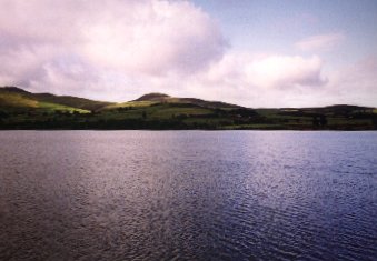
| Although we stayed in accomodation on a farm
near the northern-most tip of Ennerdale Water, we trekked around the
lakeside path to rejoin the official route along the southern edge. In
one way this was a mistake as this is a far more difficult path in some
places. At one stage we found no other way but to undertake a 12 foot
rock-climb and descent. As this is not mentioned in the book, I can only
imagine we strayed from the main path. |
 |
Once the end of the lake is reached, the path aims north to
join a forest road, which we later found out we could have
followed for the whole of the northern bank of the lake. This
road would have been far easier than the southern path. But on
reflection the trek along the road continues for another 4 or 5
miles - adding more miles to this road-trek would have brought
increased tedium: Although the country is very beautiful along
this stretch, it is somewhat unchanging.
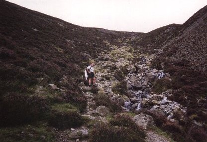 |
Coming out of the forest we eventually
reached the Black Sail Hut youth hostel. From here its
difficult to see the next obstacle - Loft Beck. This was
strenuous and difficult climb (from 240 metres at Black
Sail Hut, up to about 590 metres). We had to rest about
every 10 to 15 metres, however, this allowed us to take
in the incredible views at gradually increasing altitude. |
There seemed to be no clear way out of the top of Loft Beck,
so we just kept heading in what we thought was the right
direction. This was a very unnerving experience as we were
exhausted and didn't want to make work for ourselves. There are
streams to cross and areas of extreme steepness, slipperyness,
boggyness and loose rocks everywhere which I had to be careful
not to kick-out behind me for my partner to 'catch'. Eventually
Loft Beck is conquered and the route takes on a gentler incline.
In a way its a shame the coast-to-coast walker does not have time
to climb the peaks one passes on this route, as it would be
possible to hit over 700 metres on this day.
Finally the route begins its long descent - from here its
downhill all the way - another 4 miles. However, there were mixed
blessings when we joined the dismantled tramway: although the
path was obvious, its paved with loose shale - rocks of varying
size from small sharp pebbles to large uneven stones which take a
large boot. However, when these invariably tilt or slide when you
place your foot, and the gradient takes on an increasingly steep
downward angle. This makes for very hard walking; thankfully this
only lasts for about a mile.
One way or another the day had exhausted us and when we met
the road to Seatoller, we decided to avoid the twists and turns
of Wainwright's route and keep to the road wherever it appeared
to be shorter. This brought the wonderful sights of the numerous
waterfalls along the river next to the road.
But by the time we reached Seatoller we had made a big
decision - we were not happy. This day had been far more
exhausting than we could ever had imagined. We needed a day off,
but we had booked all our accomodation for the rest of the trip.
We decided to finish this day as planned, but get a bus tomorrow
for Rosthwaite to Patterdale. Later on we found this wasn't
possible, but in the meantime the thought of a day off kept us
going.
Back to map

timr@timandtim.co.uk
Copyright © 2000 Tim Reeves