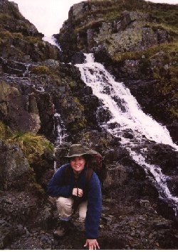
Day 3 - Rosthwaite to Patterdale
Comment: 18 miles - Only do this as 1 day if you know you can
make it
Although we had only been walking for two days, our lack of
training meant we felt exhausted. Our feet were in great pain;
not from blisters but from the sheer pounding of our feet on the
trail.
We contacted the tourist information office in Seatoller where
we were told that the only way we could get a bus to Patterdale
was via Keswick. The Coast-to-Coast walk crosses countryside and
hills without any regard for alternative bus-routes. There was
another option, however. It was suggested we bus to Keswick,
where we could get a few more supplies and some extra cash. From
Keswick we could get another bus to a place high in the hills
called Dunmill Raise. From the bus-stop at the top of the Raise
we could walk up through the pass and rejoin the Coast-to-Coast
path at Grisedale Tarn, where, it was said we could enjoy an easy
downhill hike into Patterdale.
We decided to take up this suggestion and while in Keswick we
bought some in-soles for our boots, which although expensive,
were supposed to help absorb the impacts of hiking on hard stoney
ground. When the driver of the bus dropped us off at Dunmill
Raise we felt rather unsettled, as he said he could not think of
any footpaths in that area. Furthermore, we were now in an area
not covered by the Coast-to-Coast strip-maps - all we had was a
map of the bus-route amended by the tourist information officer
of how to rejoin the Coast-to-Coast.
 |
We looked around. We could see a steep hill with no
visibly marked footpaths. We saw a style and walked to
it. Climbing over we felt a bit better - at least we were
off the main road - a more appropriate place for walkers.
From the style we could see a footpath sign about 100
metres away - I started to walk to it, but as I got close
enough to read it I could see it went back to Keswick.
After looking around some more we began to realise we
were supposed to climb the hill in front of us - there
seemed to be a slight 'beck' - where the hill had a
slight cut through it where we could avoid climbing to
the highest point. There was a dry-stone wall following
this line, however, we didn't know which side of it we
should be on. We started to pick our way over the rocks
up the right-hand side of the wall. As we climbed a
impassable gulley deepened on the other side of the wall
- a stream foamed its way downward. But the trail ahead
became more and more rocky, while the other side of the
gulley began to look more like the way ahead. Looking
back we had climbed only a small fraction of the way to
the top. We were feeling pretty down, but just at that
moment a car dropped of 3 or 4 walkers at the roadside
and they started up the base of the hill - confidently
striding - they knew where they were going ! Indeed they
took the trail to the left of the wall. |
Well, we had to retrace our steps to a place where we could
cross the stream and the wall, and then climb the hillside again
- losing sight of the walkers before we got to half way. At the
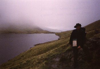
top the hill was shrouded in fog. Grisedale Tarn should be here
somewhere, and I knew if we got to it south-eastern corner the
Coast-to-Coast trail should appear. We could here voices through
the fog of the other walkers, and decided to head that way.
| Gradually out of the mist a shining, dark disc of
water appeared. At first I wasn't sure what it was. Then
I couldn't tell how far away it was - but as we decended
towards it I could see ripples on the surface through the
fog - we were still quite a way off. Grisedale Tarn is
just on the strip-map so I knew we could find the trail
from here. According to the map passes within 20 metres
of the edge of the water. But the level of the water
changes vastly depending on the rains. We eventually
found a path marked on the map which circles the Tarn,
and joins the Coast-to-Coast. It meets other paths at
several points but we took the one which appeared to be
the most well-trodden and continued along it for a short
distance. Soon we came to the outlet of the Tarn where
the trail crosses on small stepping stones. We had
found the trail ! |
 |
Although the rest of the day was downhill, the tricky
shale-path was uncomfortable underfoot. But we made it to
Patterdale, where after settling in at the guest-house we decided
again that we would have the following day off, although this
also did not go according to plan.
Back to map

timr@timandtim.co.uk
Copyright © 2000 Tim Reeves